|
|
|
 |
 | | Voxler v4 - Golden Software Newsletter(영문) |
| | | |
| 2015/10/22 (17:49) |
|
| 작성자 : 관리자
|
조회수 : 3007 |
| |
| |
| |
Newsletter #80
October 2015 | | | | |
| | |
| |
|
The month of October marks the third month in 2015 featuring a product release! The new and improved Voxler 4 boasts a number of new features including 3D DXF support, vector draping, and LiDAR support. Be sure to take the Voxler 4 demo for a test-drive as you read through the following articles that highlight these exciting new features.
In addition to Voxler's articles, Surfer and Grapher are also featured in this edition. Rick Koehler, a long-time Surfer user, details a unique way of using Surfer to create "Temporal Maps." For the non-geostatisticians, learn some gridding tips and tricks so you represent your data at its best. Finally, most of us are familiar with the 80/20 rule, also known as the Pareto principle, so see how Grapher can help you make difficult decisions easier.
We hope you find these articles insightful and useful! If you have any comments, suggestions, or a story about how you use our software let us know! |
| | | | |
| |
| |
|
We have been hard at work developing and testing the much-anticipated Voxler 4. Top new features include 3D DXF import and export, vector draping over 3D surfaces, LiDAR LAS file support, plus many more. Developed from customer comments and requests, Voxler 4 is a must-have 3D modeling and analysis package. |
| |
|
| | |
| | | |
| |
| |
|
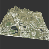
We are pleased to say 3D DXF support, Voxler's most requested feature, is now available! Importing and exporting 3D DXF files is very useful when exchanging data with colleagues and clients who do not have access to Voxler. In seven easy steps, you can import and export your files to 3D DXF. |
| |
|
| | |
| |
| |
| Quick Tip |
| |
| |
|
We recently released a new online file converter tool! Created for users in the geosciences industry, the file converter operates in an easy-to-access web browser environment and allows quick and secure conversion of image, vector, and grid files to numerous other file types. Check it out and start converting files today! |
| |
|
| | |
| | | | |
| |
| |
|
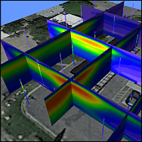
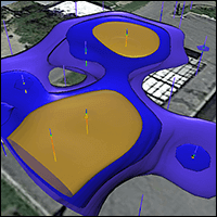
In today's increasingly visual world, the ability to create accurate representations of data is vital. As a result, new software packages and file formats are constantly emerging. Among the most common file formats are vector files. With the addition of Voxler's new vector overlay feature, your projects can now include even more detailed information. |
| |
|
| | |
| | | |
| |
| |
|
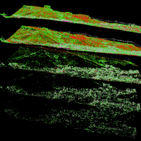
LiDAR data has many advantages over data collected with other methods, but three stand out: accuracy, density, and flexibility. Import your LAS data into Voxler for a stunning display in four simple steps. |
| |
|
| | |
| | | | | |
| |
| DON'T MISS OUR UPCOMING WEBINARs |
| |
|
November: New Features of Voxler 4 |
| |
|
|
| |
|
December: Surfer 13's Frequently Asked Questions |
| |
|
|
| | | |
| |
| |
|
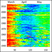
The flexibility of Surfer to plot various types of data is impressive. Yet with a change in perspective, the versatility of Surfer can be expanded even further to cover a whole new class of plots. Visual Data Analytics routinely uses Surfer to plot time-series data as image (raster) maps. |
| |
|
| | |
| | | |
| |
| |
|
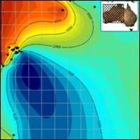
Interpolation is a vital part of the day-to-day workflow for many. Since it's often impossible to take measurements everywhere in your area-of-interest, Surfer's gridding methods take your discrete data set and accurately represent what happens between these measurement locations, so you get the complete picture. |
| |
|
| | |
| | | |
| |
| |
|
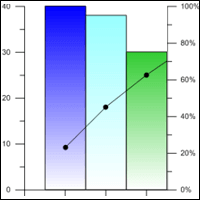
Have you ever had a problem that had many possible causes? Was it hard to decide, with limited resources, which of the possible causes were the most worthwhile to fix? Use the 80/20 rule to make difficult decisions easier when you use Grapher to create a Pareto chart. |
| |
|
| | |
| | | |
| |
| LEARN MORE ABOUT OUR SUITE OF SOFTWARE |
| |
|

Surfer Contouring, Gridding & 3D Surface Mapping |
|

Didger Digitizing & Coordinate Conversion |
|

Strater Well Log, Borehole & Cross Section Plotting | | | | |
| ?015 Golden Software LLC. All Rights Reserved. | | | | | |
|
| |
| |